<-- More Absolutely Florida

 
Above, a glimpse of the homes along Ft. Lauderdale's Intracoastal

Cruising Florida's Amazing Intracoastal
by Lynne Sheldon

The Intracoastal runs 1,095 miles from Norfolk, Virginia, to Miami, Florida, as well as specific
 

details about the 715-mile passage from Virginia to the Florida state line and about 380 miles along the entire eastern coastline of the Sunshine State.

Boaters will pass through varied boating conditions, lots of interesting history (yes, Florida has lots of it), many marinas, stunning waterfront homes, quiet sections, and busy boating lanes. It's an ideal way to see Florida by boat. Those with tall masts shouldn't have a problem, in that all but two bridges have a 65-foot clearance and those two are around 64 1/2 feet (twin highway bridges at Mile 720.9) and 56 feet (Julia Tuttle Causeway Bridge at Mile 1087.2).

The ICW enters Florida from Georgia around Mile 715. The northern section of Florida's ICW tends to be much quieter in general, with many stretches of marshes and wide rivers where there's typically little traffic. The additional attraction of interesting cities like Jacksonville and historic St. Augustine make this section one of the ICW's most enjoyable.


The first point of interest in Florida is Amelia Island and Fernandina Beach. This resort area and the marinas are often crowded, but they are well worth a stop in off-season (fall to spring). To the south, boats enter the wide St. Johns River at Mile 739.5. The bustling downtown area of Jacksonville is 16 miles upstream for those who have time to explore it. Otherwise, the ICW cuts across the often heavily-trafficked river and enters a 23.8-mile land-cut, starting at Pablo Creek.


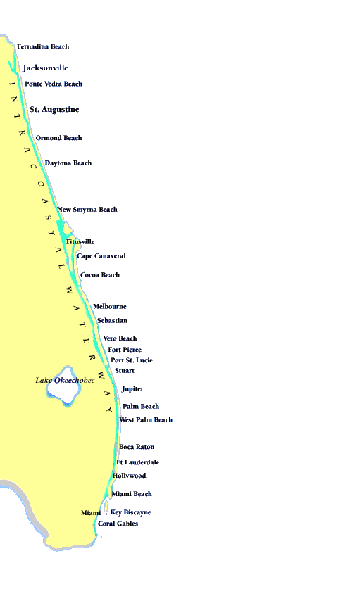
The St. Augustine Municipal Marina is at Mile 778.3 and itís an ideal base for exploring this charming city. The restored part of the downtown area and the Castillo de San Marcos are among the many highlights.

The cruise down to Daytona Beach is typically quiet and interesting with many smaller facilities and attractions. Once in Daytona Beach proper (around Mile 830), there are several marinas to serve as bases directly in the downtown area. Once a spring fling for rowdy college students, Daytona Beach has become a year-round resort haven for families, boaters, and many others.

To the south, New Smyrna Beach (around Mile 845) marks the beginning of central Florida proper. Basically, for ICW cruisers, this means the generally wide and enjoyable Indian River. At the upper end, the Indian River is about four miles across, narrowing to about 1 1/2 miles in width at the end of its 120-mile length.

This section includes the only unattended opening bridge on the entire ICW (Mile 876.7), which closes automatically when a train approaches (eight minute warning to approaching boats). Boaters will also get glimpses of the towering vehicle-assembly building (and maybe a rocket or two) at the John F. Kennedy Space Center. All along the way, boaters will also see the famed citrus groves that have made Indian River fruit world-famous
.
Several cities, including Titusville, Cocoa, Melbourne, Vero Beach, Fort Pierce, Port St. Lucie, and Jupiter, also dot the Indian River area. All make for great stops in this interesting part of Florida.
The Palm Beaches mark the start of southern Florida. From the water, boaters will enjoy view of huge homes, private docks, some serious yachts, and a large number of marinas with every service imaginable
.
Down here, one town or city essentially flows into the next, making boating traffic a frequent issue. Restricted bridges and frequently slow cruising speeds make this an area for patience at the helm.

Highlights of southern Florida boating on the ICW include the elegance of the Palm Beaches and Boca Raton, the vibrancy of Fort Lauderdale, and everything that has made Miami and Miami Beach a neon-hot destination for boaters and other visitors. The large condominium buildings will often make cruising feel more like walking in Manhattan, but itís an experience few boaters will ever forget.

Near the end of the ICW the Miami River runs right through the middle of downtown Miami. The departure point for Key Biscayne (Mile 1095) essentially marks the end of this phenomenal east coast boating adventure.


More Florida Boating Stories:

Buying a new Boat!
A few tips to narrow your search
and to make a sound decision
.

Florida Marinas
Listings of Florida marinas with interactive map

Rent or Charter, New or Used
Look before you leap

Don't Miss the Boat Show
Events throughout the state in 2000

Florida for Sail
A professional yachtsman's perspective

Dockside Dining
The best waterfrontspots to tie up to chow down, plus tips on parking


For More Information
One of the best cruising guides to the ICW is The Intracoastal Waterway, Norfolk to Miami: A Cockpit Cruising Handbook, by Jan and Bill Moeller (published by International Marine, 800/262-4729). The National Oceanographic and Atmospheric Administration (NOAA) publishes 'strip charts' for the entire ICW, but most boaters find them unwieldy to use in the cockpit. One better option is The Intracoastal Waterway Chartbook: Norfolk to Miami. Edited by John and Leslie Kettlewell and also published by International Marine, this book has reproductions of all the NOAA charts, as well as other helpful charts and information. In addition, International Marine's Tide Tables and Tidal Current Tables are highly recommended.


<