|
|
|
|
|
|
|
|
|
|
|
|
|
Gulf
Islands National Seashore
Arguably, some of the best hiking paths are the sand-lot trails
along the 70 miles of public-access Gulf beach that trek through Escambia,
Santa Rosa, Okaloosa and Walton counties. Fifty-two of the miles are
within the Gulf
Islands National Seashore (904-934-2600)
including 16 breathtaking miles that begin south of Pensacola, where
there isn't a whiff of commercial development. This is a trail lined
with sea oats and sand dunes, pelicans and sand pipers, bluffs and sea
breezes to keep your biological radiator from boiling over. Again, there
are no hills and the dunes are strictly off-limits, but if you need
more resistance walk in the Gulf to burn a little extra energy, but
remember to take off your boots. The saltwater wrecks even the finest
pair.
If you insist on leaving the beachfront
there are a few rewards awaiting.
 Holt Holt
The
Blackwater River State Forest,
(904-957-4201) offers three trails. The 21.5-mile Jackson Red Ground
Trail is part of the Florida National Scenic Trail, and has a starting
point close to the main forest entrance. The Sweetwater
Trail, 4.5 miles, is near the
middle of the 186,475-acre forest and the Wiregrass
Trail, 5.5 miles is near to its
northeast corner. There are shorter trails at Hurricane
and Bear lakes and the Krul
and Bone Creek
recreation areas. The scenery includes
long-leaf pines and scrub oaks, hardwoods and cedars, swamps and wiregrass
that more than 200 species of wildlife call home.
There are three other adlib hiking trails
in the Coldwater
Recreation Area of the forest,
adjoining the horse trails featured a little later in the chapter. Forest
Road 64 is 4.4 miles one-way; Forest Road 66 is 3.4 miles one way and
Forest Road 13 is 4.4 miles. All are seldom-traveled dirt roads.
The
Northwest Florida Water Management District,
(904-539-5999) offers trails at one property in the region. Its Choctawhatchee
River and Holmes
Creek tract has a pair of trails
going through wetlands and dry hammocks that evolved from ancient dunes.
For a guide book with maps, call or write the district at Route 1, Box
3100, Havana, FL 32333-9700.
Port St. Joe
You're about to discover this is not an area with a heavy concentration
of designated trails, particularly those that will allow you to work
up a lather. So the best bet if that's your goal is to use an improvised
one. County Road 30 leaves the Gulf County mainland south of Port
St. Joe, turning into CR 30-E
for the 21-mile (one-way) journey to the tip of St. Joseph and the far
reaches of the same-named state park. This route is well-compensated
with dune, woodland, beach and wildlife scenery and, if you're a true
stormtrooper, you can do the full-length round-trip for a heavy-duty
workout. The park has nine miles of beaches and Cape
San Blas has several miles more.
If you're inclined you can do more than half of the hike on the water.
The other improvised hike is the 1.4-square-mile
walking tour of Chipley's
historic district, (904-638-6340).
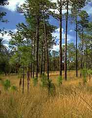
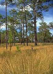
Pine Log State Forest
Pine Log State
Forest, (904-872-4175,) is one
of Florida's original forests, bought by the state in 1935-36. Pine
Log's 6,911 acres include three lakes and an environmental center near
the beginning of a three-mile nature trail that leads through slash,
sand and long-leaf pines, as well as blackjack oaks, red maples, junipers
and, for a short distance along the Pine Log Creek, cypress. It's also
a peaceful spot for bird-watching (woodpeckers, mockingbirds and hawks).
For those who decide to lay over, the forest has 20 campsites, including
19 with electrical and water hook-ups. The Pine Log area also has a
31-mile portion of the Florida National Scenic Trail. For information,
(800-343-1882).
Five area state parks offer designated hiking trails.
Chipley
Falling
Waters State Recreation Area,
(904-638-6130), has two trails. One is about .8 miles roundtrip and
passes by wiregrass, the site of an old well, the falls and outlying
sinkholes. The other trail, .6 miles round-trip, goes from the parking
area, passed the amphitheater 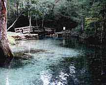 to
the 24 campsites. to
the 24 campsites.
Ponce deLeon Springs
Ponce
de Leon Springs State Recreation Area,
(904-836-4281), has two short trails: Spring Run, 500 feet from the
main spring halfway along the run to the Choctawhatchee River, and Sandy
Creek, 750 feet along the opposite side.
Marianna Area
Florida
Caverns State Park, (904-482-9598),
provides the very different perspective of hiking a half-mile course
under the surface of the planet. The park has a half-mile of trails
at ground level, too.
Three
Rivers State Recreation Area,
(904-482-9006), features a nearly mile-long, sometimes hilly trail
along Lake  Seminole.
There also is a .4-mile Half Dry Creek Trail on the eastern side of
the park. Seminole.
There also is a .4-mile Half Dry Creek Trail on the eastern side of
the park.
Port St. Joe
St.
Joseph Peninsula State Park,
(904-227-1327), offers three short trails that range from 1,400 feet
to 2,000 feet, in case you don't have the energy for the 21-mile (one-way)
marathon improvised earlier. The Gulf side trail is a link between two
camping areas that have 119 campsites.
The Northwest
Florida Water Management District,
(904-539-5999), offers trails at three properties in the region. The
Choctawhatchee River-Holmes Creek tract has two trails running through
wetlands and upland hammocks that evolved from ancient dunes.
The Apalachicola
River Management Area has seven
miles of trails through a forest floodplain inhabited by several species
of birds, including swallow-tails and Mississippi kites.
The Econfina Creek
tract has one trail site that
meanders through a diversity of flora (ash, magnolia, liverworts) and
fauna (summer tanager and a large population of warblers). For a guide
book with maps, call or write the district at Route 1, Box 3100, Havana,
FL 32333-9700.
Additionally, Tyndall
Air Force Base, (904-283-2641),
about 10 miles east of Panama City on US 98, has two short nature trails
and numerous other trails that are available for hiking. To get information
about base access or maps, call or write the Natural Resources Office,
Tyndall Air Force Base, FL 32403.
Quincy Area
It's hardly a forced march, but one place to start is the walking
tour of the historic
district in Quincy, a three-mile,
flatland tour, start to finish. You can grab a map that identifies specific
properties at the chamber of commerce's office, (904-627-9231). At certain
times, docents take groups on guided tours.
The Fort Braden
Trail in the Lake
Talquin State Forest, (904-488-1871),
has an east loop (6.2 miles) and a west loop (2.9 miles) marked in blue
paint. Maps are available at the Florida Division of Forestry, 1214
Tower Drive, Tallahassee, FL 32301.
Bristol
Torreya
State Park, (904-643-2674),
in Bristol, has a seven-mile loop that goes through the park's dramatic
ravines and other natural features. The St.
Marks National Wildlife Refuge,
(904-925-6121), has five- and nine-mile trails along US 98 in the Panacea
area and seven- and 13-mile trails near St. Marks off Highway 59. Both
travel through the marshes, swamps, flatwoods and uplands that surround
Apalachee Bay. To get detailed maps of the refuge's trails and various
access points, call or write the refuge at P.O. Box 68, St. Marks, FL
32355. The refuge also has a 43-mile section of the Florida
Trail that can be reached at two
spots: 1.1 miles west of Medart on Highway 319 or .75-mile west of the
Aucilla River bridge on US 98.
Apalachicola Area
There are several great trails located in the area, including four
in the Apalachicola
National Forest, (904-643-2282),
near Bristol on Highway 20 or, (904-926-3561), near Crawfordville on
US 319. The Wright
Lake Trail stretches 4.5 miles
through a pine forest that adjoins a cypress-lined lake. Leon
Sinks Geological Trail is three
trails totaling 5.4 miles, all of which showcase the area's wet and
dry sinkholes and hardwood hammocks. There also is a 12-mile loop trail
at Camel Lake.
The aesthetics? Otters, bald eagles, black bears and alligators are
just a few of the 400 species of birds, reptiles and mammals that live
here.
If you decide to take the short trip from Apalachicola across St.
Vincent Sound to the wildlife
refuge, (904-653-8808), there's
plenty of self-guided hiking room on the island's 14 miles of beach
and 80 miles of sand roads. The refuge office and visitor center in
the harbor master building on Market Street will give you a map that
should keep you from getting lost or storing calories.
The Northwest Florida
Water Management District,
(904-539-5999), offers seven miles of trails at its Apalachicola River
tract. They wander through a forest floodplain inhabited by several
species of birds, including Mississippi kites and swallow-tails.For
a guide book with maps, call or write the district at Route 1, Box 3100,
Havana, FL 32333-9700.
Tallahassee
Tallahassee's most notable hiking route is the Tallahassee-to-St.
Marks Historic State Trail,
(904-922-6007), a 16-mile journey along a railroad route that once connected
the two cities. A paved parking lot is located on Highway 363, also
known as Woodville Road, two miles south of Tallahassee at the north
end of the state trail.
 Alfred
B. Maclay State Gardens, (904-487-4556),
has five miles of trails surrounding Lake Overstreet, which has vegetation
such as water lilies, pickerelweed, purple cabomba, dogwoods and magnolias.
Don't be surprised when a deer, grey fox or bobcat darts across your
path. The property is located at 3540 Thomasville Road (Highway 61,
the extension of Monroe Street). Alfred
B. Maclay State Gardens, (904-487-4556),
has five miles of trails surrounding Lake Overstreet, which has vegetation
such as water lilies, pickerelweed, purple cabomba, dogwoods and magnolias.
Don't be surprised when a deer, grey fox or bobcat darts across your
path. The property is located at 3540 Thomasville Road (Highway 61,
the extension of Monroe Street).
Also, Tallahassee's
Elinor Klapp-Phipps Park, (904-891-3975),
has about 11 miles of hiking trails west of Lake Jackson. The trails
wind through land that's inhabited by wood storks, bobcats, turkey,
deer, ospreys and other species.
Osceola National Forest Area
Leading the pack is the Florida National Scenic Trail's leg in the
Osceola National
Forest, (800-343-1882) (Florida
only), 904-752-2577 and 352-378-8823. This 23-mile trail segment has
access points in two areas. The aesthetics include mist-shrouded cypress
swamps (if you start early), sawgrass marshes interrupted by hardwood
hammocks, vast pine forests and crystal-clear springs. You will find
20 boardwalks, from which you can watch nature, including local wildlife
ñ turkey, deer, grey fox, American swallow-tail kite, red-cockaded
and pileated woodpecker, warblers and Bachman's sparrows.
Carter Camp
is a six-mile trail in the Stephen
Foster State Folk Culture Center,
(904-397-1920), in White Springs.
The Big Gum Swamp
Wilderness Area, (904-752-2577),
has a pair of primitive trails worthy of note inside the Osceola National
Forest. A 6.2-mile trail begins at an entrance off Highway 262 (from
US 441 in Lake City head north to Highway 262, turning right or east
nine miles to the trail entrance). The other, a three-mile loop, begins
off Highway 250. The scenics on this trail include cypress-gum swamps,
pine flatwoods, shallow sloughs and, if you're sharp-eyed, the remnants
of a turpentine still.
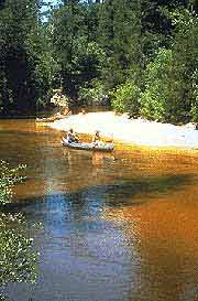
Suwannee River Area
There are several additional hiking paths in the Suwannee River
region, including:
Twin Rivers State
Forest, (904-208-1462), an eight-mile
trail along the river that provides glimpses of sinkholes, wildflower
carpets and stands of American elm, sweet gum, hickory, river birch
and bald cypress. To get to the forest from Madison, head east on US
90 about 16 miles to the outskirts of Ellaville. Note: If you pass a
state agricultural inspection station you've gone about one mile too
far east.
The Holton Creek
Trail, 16 miles, includes a first
magnitude spring, dozens of sinkholes and outcroppings, two state champion
cypress trees, plus oak, hickory, magnolia and beech.
The Mattair Spring
Trail, 11 miles, includes very
high limestone banks and an occasional patch of white sand beach.
Camp Branch
is a six-mile trail with bluffs, ravines, floodplain areas and sinks
where the branch run disappears underground.
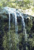
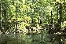
Ichetucknee
Springs State Park, (904-497-2511),
offers two short trails. The two-mile Pine
Ridge Trail, which is located
off the river's run, forms an oval around sinkholes, hardwood hammocks,
sandhill and long-leaf pines, wiregrass and various sprouts of lichens.
The .7-mile Trestle
Point Trail parallels the river
for part of its path, then ventures to abandoned phosphate pits, an
old railroad trestle and the tram road. Wildlife in the park ranges
from gopher tortoises and frogs to river otters and flying squirrels.
 Suwannee
River State Park, (904-362-2746),
has five hiking trails (Lime Sink, Suwannee, Balanced Rock, Sandhills
and Earthworks) that can be tackled as one trail (2.93 miles). Combined,
the trails wander along the river, the old ferry landing, Lime Sink's
beaver colony - if you can't spot the beavers, search for the teeth
marks they leave on standing trees and the Columbus Cemetery. (Sorry,
this isn't the graveyard where Christopher is buried. It's the final
resting place for those who settled an old riverboat town.) Suwannee
River State Park, (904-362-2746),
has five hiking trails (Lime Sink, Suwannee, Balanced Rock, Sandhills
and Earthworks) that can be tackled as one trail (2.93 miles). Combined,
the trails wander along the river, the old ferry landing, Lime Sink's
beaver colony - if you can't spot the beavers, search for the teeth
marks they leave on standing trees and the Columbus Cemetery. (Sorry,
this isn't the graveyard where Christopher is buried. It's the final
resting place for those who settled an old riverboat town.)
Additionally, the Suwannee
River Water Management District,
(904-362-1001) or (in Florida) 800-226-1066, provides several good trails
throughout this region, including the following ones along the river.
Little Shoals Tract,
a 2-mile marked trail, which has small rapids in an area where early
explorers and American Indians crossed the river.
Big Shoals Tract,
2 five and three-mile trails along high bluffs, large rapids, limestone
outcroppings, tupelo and wild azaleas.
Gar Pond Tract,
six-mile marked trail through river sloughs, wet prairies and a sinkhole.
|