|
|
Click the city of interest on the map for a list of the public beaches and thier parking facilities
Door-to-Door
![]()
![]()
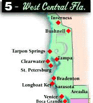
West Central Florida
Beaches
Tampa / St. Pete profiles Clearwater Beach profile Sarasota profile
Follow the ![]() for pet-friendly beaches.
for pet-friendly beaches.
St. Petersburg area
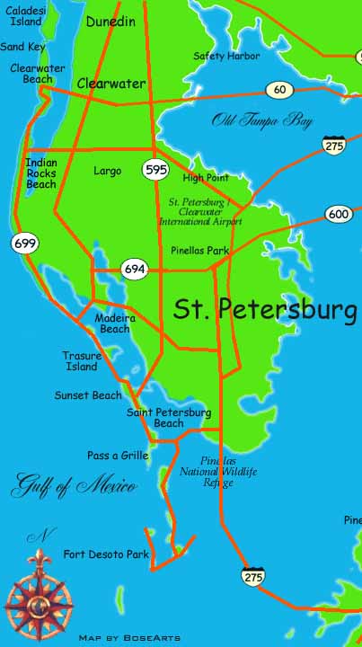 This section of Gulf coastline defines the western edge of Pinellas (PY-nellis) County for more than 23 miles. Check the map on the right.
Caladesi Island. Reached only by pontoon ferry, this 3-mile-long, untouched barrier island is near Dunedin, toward the northern edge of the county.
Sand Key. Just a few miles south of Caladesi, this smallish park fulfills the dream of a tropical paradise.
Fort DeSoto Park ![]()
Seven sprawling miles of beach and recreation area; an old historic fort, with overnight camping, lots of barbecue grills and picnic tables under shade pines, the occasional raccoon and snake..
Exit Interstate 275 at State Road 682. Turn south on State Road 679. Two tolls. Paved trails; bike rentals, snack bars, boat ramps, picnic areas with grills, rest rooms, free parking and camping (with reservations).
Pass-a-Grille
A national historic district with quaint beachside hotels and the pink Don CeSar, with a 1920s-era four-star Mediterranean hotel. Funky beach fun. I-275 at State Road 682, west to the beaches.
Street parking, beachside restrooms
Clearwater Area
Sand Key Park
I-275 to State Road 60, west to Clearwater Beach. Or take I-275 to State Road 688 in St. Petersburg and turn north on Gulf Boulevard.
Wide beaches, covered picnic areas. Grills, restrooms, metered parking. For the college crowd, it's Clearwater Beach (north of Sand Key).
Indian Rocks Beach ![]()
I-275 to State Road 688
Madeira and Redington beaches
I-275 to 38th Avenue North
Treasure Island
I-275 to 5th Avenue North